
Earth-i · Defence & Intelligence platform
VANTAGE - defence intelligence at speed
The problem
By the time the defence report arrives, the picture has already changed
Satellites now revisit most sites several times a day. But raw satellite imagery isn’t intelligence – turning a picture into a usable report for defence analysts still takes hours of expert processing, and finished assessments routinely land days late. Most of an analyst’s time goes on counting and collating, not on judgement.
The shift
VANTAGE turns satellite images into operational defence intelligence in minutes, not days – combining commercial imagery, AI object detection, orbital tasking and the VERA assistant in one platform.
What VANTAGE does
Detect. Monitor. Decide.
From every satellite pass to a decision you can act on – three things the platform does automatically, for every site you watch.
Counts, not guesswork
Automatic, AI-verified counts of aircraft, vessels and vehicles from every satellite pass — no manual counting.
Per-type classification from very-high- and high-resolution imagery, identifying specific platform types.
One score per site
A clear, comparable activity score for every site, updated with each new image, with automatic alerts when something changes.
Normalised 0.0–1.0 activity index, change logs and trend baselines refreshed on every new scene.
Know the next window
Know when the next usable satellite window is before you commit tasking resources.
Overpass predictions across 11 commercial operators, with viewing-angle banding and alerts for gaps when no good collect is possible.
The dashboard
Every monitored site, one screen
A single view across all your sites – on land, at sea and in the air. Live threat status, last-updated time stamps, and one click from any site to its full intelligence report.
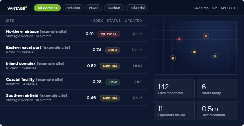
Threat levels (Critical / High / Medium / Low) are driven by the live activity index · domain filtering (e.g. strategic aviation, naval, nuclear, industrial) · every area-of-interest time-stamped in UTC · scales to thousands of sites with no architectural change.
Capabilities
Five capabilities, one platform
Each does one job in plain terms. Open How it works for the technical detail.
01
Activity Index
A single, comparable score that shows how busy a site is — and flags significant change automatically.
HOW IT WORKS
- AI detection runs on every collect; results normalised to a 0.0–1.0 index for cross-site comparison.
- Alert markers fire on defined thresholds, so significant change surfaces without manual review.
- Draggable time window with 6M / 1Y / 2Y / All presets for trend review.
02
Aircraft Detection
Machine-verified aircraft counts replace manual counting and analyst memory.
HOW IT WORKS
- AI classifies fixed-wing and rotary-wing aircraft from VHR and HR imagery.
- A per-observation log records date, counts, change vs previous, and source sensor.
- Threshold breaches trigger a significant-change marker on the timeline.
03
Imagery Coverage
Every image of a site, catalogued in one place — what took it, how sharp it is, and how cloudy it was.
HOW IT WORKS
- Six sensor classes — very-high / high / medium-resolution, optical and radar.
- Cloud-cover bands from clear to heavy, so usability is obvious at a glance.
- Full acquisition timeline and monthly revisit-frequency chart.
04
Satellite Tasking Intelligence
See the next viable imaging windows for a site before you spend money tasking a satellite.
HOW IT WORKS
- Overpass predictions calculated from live orbital data (updated daily) across 11 commercial operators.
- Viewing-angle (off-nadir) banding — optimal / acceptable / marginal.
- Critical-gap alerts when no usable collect is possible.
05
VERA — the built-in assistant
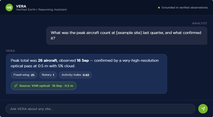
Ask a plain-language question about any site and get a structured, sourced answer in seconds.
HOW IT WORKS
- Natural-language interface over all VANTAGE data — no query language needed.
- Every answer grounded in and linked to a verified observation or source.
- Available for every monitored site, on demand.
VERA assistant
Ask in plain English. Get a sourced answer.
VERA — the Verified Earth-i Reasoning Assistant — answers questions about any monitored site, and links every figure back to the image that proves it.
Why Earth-i
A live platform, proven in the field
Not a research demo. Operational detection, real heritage, and a system you can deploy today.
Proven AI
Detection models validated against real sensor data across multiple theatres; per-type classification; sub-metre to ~3 m capability; fully auditable detection logs.
Operational heritage
Delivering geospatial intelligence to government, defence and commercial customers since 2014; direct relationships with major commercial operators (Planet, Capella, ICEYE, Maxar, Airbus); cleared personnel and secure data handling.
A live platform, not a prototype
Deployable today; configurable for any site worldwide; API-ready for existing command-and-control and intelligence systems; new sites live within days.
Next steps
Three ways to start
Pick the depth that suits you. Every route begins with the enquiry form on the right.
Demonstrate
Request a live demonstration against a site of your choice.
Pilot
Commission a 30-day pilot: monitored coverage of up to three sites with full reporting.
Integrate
Embed Earth-i detections into your existing workflow via API.
Start with a demonstration. Use the Get in touch form to tell us the site or domain you’d like to see — the team will respond within one business day.